


Land Survey Symbols Bluebeam Tool Set
Land Survey Symbols Bluebeam Tool Set
Couldn't load pickup availability
Tool set of land survey and site plan markups for marking up survey plans, site plans, and utility drawings. This tool set covers 12 categories with 338 tools, available in both black and redline versions. Every symbol is a group of native Bluebeam markups — lines, polygons, circles, and text boxes — so it can be moved, resized, rotated, and recolored directly in Bluebeam, or ungrouped to change a part. Every tool is named after its legend row, so placed markups list and count by name in the Markups List. The utility and feature lines are native Polyline markups with their own line styles, and the paving and restoration areas are native Polygon markups with hatch patterns.
Examples of tools included:
-
Site symbols and site features
- Electricity, telecom, and comms pits, pillars, and poles, light poles, and traffic signals
- Water meters, taps, stop valves, and hydrants
- Stormwater grates, pits, and manholes, sewer manholes and inspection points, and grated and kerb inlet pits
- Benchmarks, ground control points, permanent marks, state survey marks, and reference marks
- Bollards, bins, signs, gates, mailboxes, parking meters, cameras, and vehicle and pram crossings
- Site features with their legend abbreviation: SMH, SIP, HYD, WM, KIP, GIP, PP, ELP, and more
-
Services and street furniture
- Electrical, telecom, and optical fibre pits, pillars, markers, and poles
- Gas mains, meters, and valves, sewer manholes, lampholes, and vent pipes
- Water air valves, hydrants, meters, pumps, stop valves, and taps
- Drainage gully pits and manholes, traffic lights, traffic junction boxes, and signal controllers
- Seats, bus stop signs, flag poles, post boxes, trees, and shrubs
-
Survey legend symbols
- Water valves, valve markers, scour, reflux, and air valves, reducers, end caps, tee junctions, and sample points
- Sewerage, stormwater, telecom, water, and gas manholes
- Survey stations, permanent survey marks, benchmarks, and bore holes
- Hydrant markers, fire hydrant pillars, hose reels, gully traps, guide posts, and street name signs
- Trees, palm trees, and shrubs
-
Existing and proposed utilities
- Existing wastewater and storm manholes, catch basins, cleanouts, water and power meters, gate valves, fire hydrants, power poles, guy wires, TV pedestals, gas valves, luminaires, signs, and trees
- Proposed communication structures and pedestals, wastewater and stormwater manholes and cleanouts, catch basins, drop inlets, reducers, caps, bends, couplings, tees, electrical boxes, utility poles, roof drain connections, trees, and monuments
-
Survey points and monuments
- Benchmarks, bounds, iron pins, drill holes, station marks, marker points, and high and low points
- Test pits, wells, water shutoffs, utility and guy poles, and flared end sections in plan and profile
-
Utility lines
- Lettered service lines: water (W), sewer (S), stormwater (SW), storm (ST), sanitary (SS), drain (D), gas (G and GAS), fuel line (FL), electricity underground (E) and overhead (P and ELECT), underground and overhead power (UGP, OHP), communications (C), telecom (T), fibre optic (FOC), underground and overhead telephone (UGTEL, OHTEL), underground and overhead cable TV (UGCATV, OHCATV), and cut/fill (C/F)
- Fence lines with X, slash, and circle marks
- The lettering stays upright along the line and grows with the line width
-
Feature and boundary lines
- Top and bottom of wall, drainage channel, change of grade, road bitumen edge, kerb and channel invert, kerb lip, kerb top front and back, concrete edge, double building line, and HV transmission line
- Dashed, hidden, center, phantom, and long dash lines
- Existing linework: right of way, centerline, edge of pavement, double curb, storm, ditch, sanitary, water, gas, overhead and underground telephone, power, and cable TV, overhead wire, fence, and double wall
- Proposed linework: centerline, double curb, storm, sanitary, water, gas, sawcut, fence, underground power and telephone, approximate cut/fill line, right of way, public utility and temporary construction easements, drain curb, and phase line
-
Hatch patterns
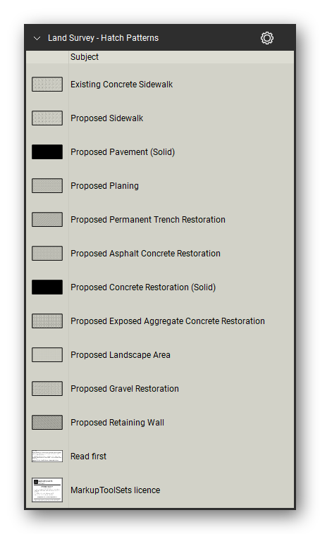
- Concrete sidewalk, planing, permanent trench restoration, asphalt concrete restoration, exposed aggregate concrete restoration, landscape area, gravel restoration, and retaining wall
- Solid pavement and concrete restoration fills
- The 45 line styles and 8 hatch patterns are also included as a line style set and a hatch pattern set for any other markup
Delivered as a Bluebeam Revu profile that loads all 12 tool sets, the line style set, and the hatch pattern set in one import, plus the individual tool set files, in black and redline.
How to use
- Import the profile (Revu > Profiles > Manage Profiles > Import, or double-click the .bpx file), or import single tool sets from the Tool Chest (Manage Tool Sets > Import).
- Symbols: click a tool, then click the sheet.
- Line tools: click a tool, then click from point to point and double-click to finish — any length, any number of bends.
- Area tools: click a tool, click around the area, and double-click to finish.


Let our customers speak for us
Let customers speak for us

It was extremely helpful in marking up a road closure and was needed by the city of New Haven to properly have sign placement as per their direction

We rely frequently on the section shapes for our steel detailing.

As someone who averages more than 4 hours a day on Bluebeam, these tools have been a life-saver!
